Top-Down-Optimization
In area planning, not only is work done on small-scale areas to higher-level structures, but also on coarser, higher-level structures that are to be broken down into smaller-scale, lower-level structures.
One application case for top-down optimization is when supraregionally structured sales divisions are to be subdivided into small-scale sales territories, each of which is optimized according to potential or territory size. The supra-regional sales divisions are to be retained in their size and spatial boundaries.
Note: This variant of territory optimization requires a multi-level territory structure. This means that at least two area levels are placed on the brick level. The top level must also already contain territory.
The new approach becomes clear when one looks at the previous "bottom-up" area optimization: Districts are grouped into larger units - here into regions (clearly separated by a red border representation in the second image).
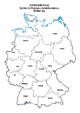
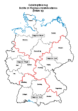
The new approach to territorial planning is based on the assumption that the fine level of the areas is only rudimentary and that only the regions are fixed.
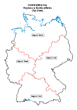
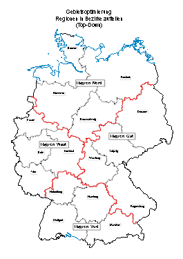
Theory explained using an example
In the following example, we explain how you can use a top-down optimization as an example.
Define the structure of the territory
The territorial structure is based on postal code areas in Germany. The superordinate level of the regions should correspond to the borders of the federal states. So that the borders of the federal states can be transferred into the territory structure, you should insert the base map of the federal states on the sheet to the postal code areas.
- Create the territory structure with two levels - districts and regions. Both layers remain empty at first, which is why you can click directly on Finish after defining the layer.
- Using the context menu for the Regions layer, call the submenu item Borders of regions such as layer... in the Edit menu. Then select the desired map to which the regions should be adapted as best as possible (here the federal states). Since both territorial levels were empty, they are now filled and correspond approximately to the federal states.
Start Top-Down Area Optimization
Using the Top-Down-Optimization each region can now be split into its own number of districts. The number of districts per region can, for example, be calculated from data or a value can be given for the approximate number of bricks contained per district (here: postal code areas).
- Select the level of the regions and start in the context menu Optimization the Area optimization and select in the opening dialog the Top-Down-Optimization.
Defining Optimization Criteria
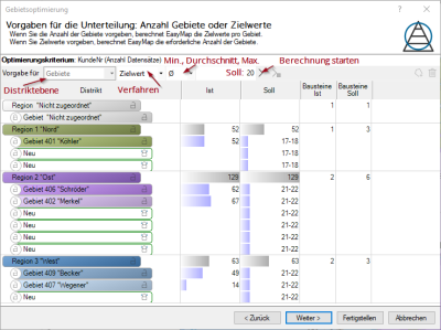
In the next step, define the criteria according to which the territories to be recalculated (here: districts) are to be optimized:
Specifying target values for the subdivision
In this example, the number of customers per area should be equal to a certain average target value.
Note: The target value from which the number of carrier routes per region is to be calculated is a guide value. The spatial distribution of your data clearly contributes to how the area size is calculated.
| Optimization criterion |
The Optimization criterion displays the column selected in the previous window for the optimization. |
| Territory Layer |
Select the layer to be optimized here. Only adjustable if there is more than one subordinate level. |
| proceedings |
Target value: the number of territories is calculated data-controlled. Count: the number of territories can be specified. |
| Minimum, Average, Maximum(only available if value was previously set in Procedure) |
Here you can set how the number of sub-territories is to be calculated from the target approximate value. For each territory, the available volume is divided by the target approximate value. From this the number of necessary territories is calculated as follows:
Note: This calculation does not guarantee that all territories will be above or below a certain value. Since the bricks can only be assigned to one or the other territory as a whole, it can happen that some territories fall below the border, while others cross the border. The more bricks there are and the more homogeneous the value distribution is, the more likely it is that the territories produced will be close to the target value. |
| Target: | Depending on the selected procedure, you can enter the number of territories to be created or the target value to be reached (from the selected data column). |
| Execute | Executes the defaults. |
| For <Marked Territory> execute | Executes the defaults only for the territories you selected in the list. |
Manual
In addition to this automatic calculation of the territory and your target value, you can manually delete or add marked territories.

|
Select a territory of the superior level and add a new subordinate territory. The target values are adjusted accordingly. |

|
Select a territory to delete it. |
