Geocoding
This function determines a coordinate from various components of an address. The more components are specified, the more precisely the coordinate can be determined. The address geocoding function enables you to display a rectified display on the map for small-scale analyses. Your sales territories become even more finely adjustable. It can be triggered either directly when creating the analysis (location-based) or in advance in your table, which you have imported or linked in easymap.
Geocoding variants
easymap offers a variety of different ways to encode your address. Here you get an overview of the integrated possibilities, as well as the advantages and disadvantages of each variant.
You can find out how to geocode the addresses in the Data Concept chapter under Calculations.
Rastered geocoding (DACH) - Placement via address
You can position your customers via their address in a 100 meter grid. This enables you to display the data on the map in a straightened way for small-scale analyses such as symbol analyses. This geocoding only works with addresses from Germany, Switzerland and Austria.
Note: The grid used corresponds to the Inspire 100 m ETRS-LAEA grid. The grid allows addresses that are close together to fall on the same gridded coordinate. You can find more information on this here.
Address accurate geocoding - worldwide and unrastered
Here, worldwide addresses can be processed instead of only addresses from Germany, Austria and Switzerland. In addition, the positioning for many countries is carried out accurately and unrastered. Depending on the country, the accuracy varies*. By evaluating the address quality it can be determined what accuracy the geocoding has.
*For some countries, including South Korea and Japan, only localized positioning is available.
Note: The available options are determined by the license you have purchased. This function is only available if you use the extension easymap office pro own. For each geocoded address, a credit from your easymap office pro Contingent deducted. If your number of Credits is used up, the address specific geocoding will be replaced by the rasterized geocoding again. The additional functions as well as the number of Credits included in your license can be checked via menu > ? > via easymap > additional functions. For more information about the licenses, contact us please.
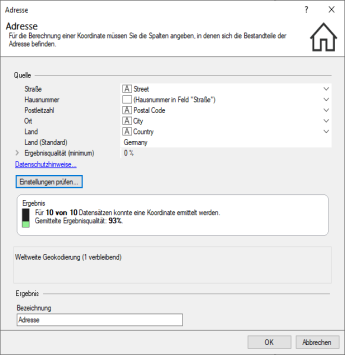
The type of geocoding used is displayed in the address geocoding settings dialog:

