Data gathering
A good preparation of the data is crucial for the success of the map! easymap offers various, universal data interfaces for import or for linking data. However, easymap does not include possibilities for data acquisition. Therefore, please use your standard software (database, spreadsheet, statistics package etc.) for data acquisition.
The following hints and tips should help you to optimize your own data for the use in easymap.
Perform complex calculations externally
easymap offers some functions for data calculation. The scope of services of an Excel or a database program can, however, understandably not be included in a program specialized in map graphics such as easymap. Therefore, before transferring data to easymap, perform all complex data calculations (e.g. indices, quotas, target/actual deviations, shares, ...) with your standard software.
Primary Key
For some functions easymap needs a primary key in the data. This key is used for unique identification of the data. Therefore, a column to be used as primary key must contain one entry in each line; all values must be different (i.e. duplicates are not allowed). Possible primary keys are, for example, customer numbers, postal codes, municipality codes, and the like. In database tables, a primary key is often defined. easymap then automatically adopts this primary key. Another primary key cannot be used for such a table.
Note: With location-specific analyses, the symbols and diagrams resulting from this table can be moved and their properties (e.g. display with original position or labeling) can be individually adapted.
Table structure
Create your data in a two-dimensional table, where the rows reflect the geographical structure of the data, while the columns contain the attributes and data values (database tables are not called rows, but records; columns are called fields). With text files and tables from spreadsheet programs (such as Excel), make sure that all lines have the same structure and that different data types do not occur within a column (for example, numbers and text mixed together).
Note: easymap has no limit for the number of rows or columns in the data table. It is not necessary to sort the data for the transfer to easymap.
Provide data in a suitable file format
The handiest way to transfer data to easymap is often to copy the data to the clipboard (e.g. mark data cells in Excel and then copy them). easymap can then import the data from the clipboard. Of course easymap can also read standard formats (e.g. xlsx/xls, accdb/mdb, txt, csv). If your data is available in a format or in a system that is not supported by easymap, export your data to a suitable format or to the clipboard or make the data available via ODBC interface.
Tips for Using Excel Tables
If Excel tables are designed "ready for printing", they are sometimes difficult to process for easymap. Elaborately designed, multi-line column headers or pre-columns, connected cells as well as multi-line totals rows and footnotes can cause easymap to not always correctly recognize the structure of the columns that contain the actual data to be used. In such cases it is recommended to define the main set of figures in Excel as Named Range.
Avoid columns that contain different data types (such as text and numbers) or differently formatted content. For example, if Excel provides a number column for easymap, but some of the cells contain texts, Excel will provide empty cells instead of texts. This problem occasionally occurs when users have not found any other way in Excel to display postal codes with leading zeroes than to enter the postal code as text.
If an Excel table is password protected, it can be imported into easymap. During the import you will receive an error message that the file does not have the expected format. In this case save the Excel table without password protection or use the clipboard.
What to do with P.O. box and large recipient postal codes?
The digital postcode maps usually only contain the areas for the delivery postcode part numbers. P.O. box and large recipient postcodes are not included in the maps, nor are other special postcodes (e.g. promotion postcodes). When using postcode maps as base maps, this means that all data that does not contain a delivery postal code cannot be assigned to the map. Remedy: If your data source (e.g. the customer database) contains separate fields for delivery and P.O. box postal codes (e.g. delivery address and billing address), please select the field containing the delivery postal code for use in easymap. If this selection option is not available, you can use easymap to convert German P.O. box and bulk recipient postal codes into delivery postal codes.
It goes like this:
In addition to the address data, import the Excel file, which is delivered and installed together with the digital postcode map. This is located in the directory in which the digital postcode map is also installed. You can find this directory by clicking on the arrow in the upper right corner of the control window Base Maps.

You can also open the table directly via the context menu More Information in the control window base maps. The file has the same file name as the digital postcode map and the extension xlsx (e.g. DPLZ1612.XLSX). The Excel file contains various spreadsheets. The required information can be found in the worksheet Assignment to delivery postcode. It contains each valid 5-digit postcode in column A, the type of postcode in column B and the assigned delivery postcode in column C (for P.O. box postcodes, this is the delivery postcode to the P.O. box location, for large recipient postcodes, this is the delivery postcode to the company location). When importing the table, please remember to format columns A and C in easymap with the format postal code (Germany).
In the table that contains the postal codes that cannot be used, add a data column with the Lookup Using Reference Table function.
The figure shows the necessary settings:
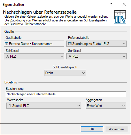
In this example, the new column is named "Delivery postal code". In this example, the column with the non-usable postal codes in your original table is called "Postal Code". The external data table "Assignment to delivery postal code" is used as the reference table. For all postal codes that are found in the key column in the reference table, the value is taken from the value column and entered in the new data column in your original table.
Geocoded data
Enrichment of address databases by geographic coordinates (longitude and latitude), e.g. with the LT GeoCoder. The addresses are not only geocoded, but also validated and provided with extensive documentation of the quality of the geocoding.
Fields of application:
- precise visualization of locations in maps
- Location and branch network planning
- distance calculation
- Planning of visit tours in the field service
For further information or an online presentation on the LTGeoCoder please visit our website.
To geocode worldwide addresses and directly in easymap, the additional function easymap pro is available. For further information, please contact us. easymap professional available. For more information please contact us.
