Data Import and Link Wizard
The wizard for importing or linking data guides you in individual steps from the selection of the data interface to the format and column settings. Start the wizard via the menu Data > Import or Link or use the corresponding icon buttons in the Toolbar.
Data interfaces
easymap offers you the following data interfaces:
- Data packages (PKG)
- Microsoft Excel workbook (XLSX, XLS, CSV)
- Microsoft Access database (MDB, ACCDB)
- Clipboard
- Text files (TXT)
- infas 360 Data API
- ODBC data source
- Microsoft SQL Server Database
- Oracle database
- OData Data source
- DistrictManager Project (DMP)
- Sharepoint List
- Microsoft Office Outlook Contacts
Depending on the data interface, the following steps differ slightly from each other. First, you are asked for the path to the data source or, for database interfaces, for server addresses or service sources.
When importing from Excel, for example, you can control the file via the Windows Explorer. Then you can select the desired spreadsheet or a named area. With Access data sources you can also access Queries in addition to the tables.
Note: Some interfaces will not be displayed until this option is available.
Note: You have purchased a data package, but it is not offered for import, please look here.
Define the format of the individual columns (Column settings)
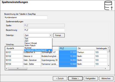
This step of the wizard is the same for all data interfaces. Here you define the names and column settings for working in easymap.
Name of the table in easymap: here you can assign a different name to the table in easymap than in the data source Please note that tables must not have the same name as tables already imported.
Column settings
The column settings always refer to the column marked at the bottom of the preview area. You can also select multiple columns at once to change their settings.
- If you do not need the data from certain columns, select the relevant columns and check Do not import column.
- Next to the term column easymap specifies the name of the selected column in the data source. Under name the user can enter what the column header in easymap should be called.
- The Data type allows you to define the individual columns for instance as Text or Number and thus enable calculations (for numbers).
Note: The data type cannot be changed retroactively.
|
Text |
This format is used to import all columns that contain text, e.g. place names, letter-number combinations, etc. |
| Number |
Only the columns that are imported as numbers can be used for calculations. Here you can also define the view of the column with addition (such as € or %) decimal places. |
| This format is used to import columns that contain date or time information. Via Format... you can select how the date is displayed in the table and map. | |
|
True/False |
Boolean value - Indicates whether the line contains a value or not. |
|
Area ID |
For a number column, you can define the length of the number with the number of digits in the format. Columns that are imported as numbers cannot be used for calculations or analyses (e.g. area-related evaluation with circle sector diagrams) or are not offered at all. |
|
Postcode (Germany) |
A predefined number that automatically displays the selected column as a number with 5 digits. If there are 4 digits in the selected column, the missing digit will be added as zero in front. |
|
WGS84 coordinate |
A predefined formatting for geographic coordinates. |
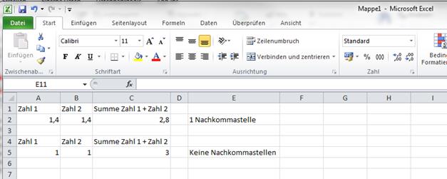
Note: You can specify the number of decimal places in the columns with the data type number so that the displayed numbers are rounded up or down. However, only the view will be adjusted for the display in easymap and not the value itself! Similar to Excel, you can adjust the view of columns with more or less decimal places. Again, you do not change the values, but only the view of the cell.

Define Primary Key
In the last step of the wizard, you can specify a column from your record as the primary key. Basically, any column that contains values in each row and in which no values occur twice is suitable as a primary key.
With location-specific analyses, the symbols and diagrams resulting from this table can be moved and their properties (e.g. display with original position or labeling) can be individually adapted.


