Geocoding
With geocoding in easymap office pro, you now have the option of geocoding in Germany, Austria and Switzerland as well as worldwide geocoding and switching between the two services at any time, in addition to the raster geocoding supplied as standard.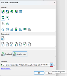
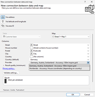
When you establish a new link between data and a map (e.g. when creating a symbol analysis), you can choose between two additional geocoding options under the ‘Service’ heading in the advanced placement settings (accessed via the ‘+’ icon next to the drop-down menu). You can choose between house-level geocoding in Germany, Austria and Switzerland, and global geocoding, which also operates at house-level depending on the country.
Using the added address column, you can access the address’s precise coordinates – down to the house level – as usual. Further information on geocoding can be found here.
You can also set the default geocoding in easymap's global settings.
To do this, click on Extras > Options in the main menu. In the tab Tables you will find the sub-item Geocoding and under Service you can select the geocoding service of your choice as described above.
The available options are determined by the license you have purchased. This function is only available if you use the extensioneasymap office pro or easymap professional. For each object drawn, credits are deducted from your quota. The more data records your table contains, the more credits will be deducted.
