Control Window: Base maps
The control window base maps displays all base maps from the selected and displayed directory. The maps are displayed grouped in a tree view. The respective groups can be opened and closed as usual in the tree view.
Which maps are available?
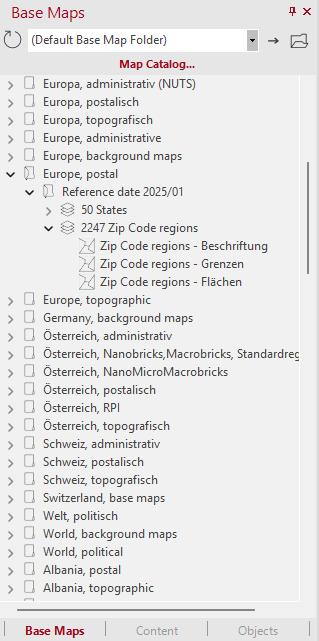
- The main group consists of the standard maps included with easymap. These are sorted alphabetically by country and content. If different versions of a map base are installed, they are displayed separately (see figure).
- If the selected directory also contains files in formats other than the easymap standard format LTG (e.g., Shapefiles, project files from earlier versions of DistriktManager, Refx files), these will be listed in their own separate groups.
- The Demo Maps group contains all the maps that can already be used with the demo version of the software. Some of them are also used in the Tutorial.
- Another point to consider is the background maps. Background maps serve to enhance the visual presentation and improve spatial orientation. While they are not strictly necessary for the mathematical analysis of your data, they provide valuable contextual details. By displaying road networks or topographic features, the location of sites and areas can be intuitively grasped and placed in a real-world geographic context.
- The group Other contains all *.LTGs that could not be clearly assigned to any other group.
Map catalog
In our map catalog , you will find all available maps, which you can order directly from us. To do so, simply click to open the map catalog. A new window will open titled Install Maps and Data. There, you can browse our selection and directly access the corresponding order form. If you have any further questions about the product, click on Inquiry. You will receive the contact information for your contact person.
The standard path of digital maps
The directory Default path of the digital maps is available, which displays the pre-installed maps and is defined during the installation. The path can be changed via the menu Extras > Options in the tab General to an alternative path.
The map layers can be added to the sheet in the center of the program window using drag-and-drop.


Selecting the base maps
- First select a structure (e.g. Germany, postal), the time level and the details of the map (e.g. postal code areas) from the set path and the base maps offered to you.
- To insert a complete base map (consisting of an area level including complete topography), click on the heading above the individual content levels (e.g. "8205 postal code areas") and drag it with the mouse from the base map window onto the sheet in the map window (Drag&Drop).
- You can gradually add more layers. To insert a single layer (e.g. federal states - borders) drag it by Drag&Drop from the base maps window onto the sheet in the map window.
Insert via context menu or Insert menu
For more options on how to create a new map and insert map backgrounds, see the context menu for the Map Backgrounds control panel and the Insert menu.
If the sheet already contains a map, the new layers can be inserted either as additional layers in the existing map or as a new map on the sheet:
- base maps are inserted as additional layers into the existing map if the mouse button is released while the mouse is pointing at the map.
- base maps are inserted as a new map on the sheet if you release the mouse button outside the existing maps or if you release the mouse button on a map while inserting the map, but simultaneously press the Ctrl key on the keyboard.
Excel tables for base maps
For each base map (LTG) an Excel spreadsheet with important information about the base map is supplied as standard. The tables contain numbers and names of all areas of the respective base map. In addition, some other useful information is provided in these tables. For the postal code areas, for example, the assignment to the delivery postal code and a history of the area changes are contained. The table can be accessed via the control window base maps. Right-click on the map layer you want, and then click More Information. The appropriate table then opens. The Excel tables are saved by default in the standard path of the digital maps for the respective base maps.
Separation of topography and map base
Starting with edition 2014 the base maps, which are part of the easymap scope of delivery, only contain areas, boundaries and the labeling of the areas. The topographic contents (cities, highways, federal roads, rivers and lakes) have been removed and stored in separate base map files. This separation of the map contents allows optimal presettings for the scale dependent visibility of the objects. In the control window base maps this separation can be recognized by the fact that the topography is no longer listed with the areas.
In order to offer unchanged comfort despite the extraction of the topography, the new base maps files contain cross references to the corresponding topography files. When inserting a new base map, easymap asks you if you want to insert the corresponding topography. If you later insert further base maps that refer to the same topography, easymap will not ask you again. This prevents that the same topographic content is inserted unnecessarily multiple times.
For map templates that include administrative levels, labels, boundaries, and areas can be inserted separately starting with the 2014 edition. This can be useful, for example, if county boundaries—which also serve as state boundaries—are highlighted as state boundaries, and you therefore only want to insert the labels for the federal states.
All topographic content can be found in the control window base maps under Germany, topographic.
