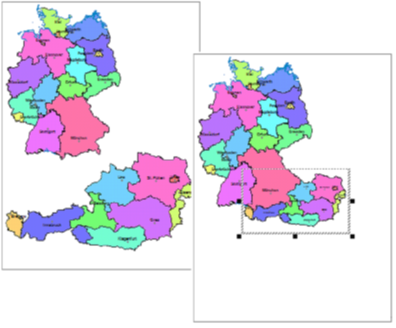
Scale-dependent map image
The Map Scale is the scale of the map relative to the sheet size. In this scale the map will be printed if the sheet is not enlarged or reduced.
The View Scale is the scale of the map relative to the screen size. At this scale, the map is displayed on the screen.
If the automatic zoom function is activated, the view scale is decisive for the visibility or invisibility of the map contents, otherwise the map scale is decisive. Further information on the significance of map scale and view scale, especially in connection with the automatic zoom, can be found in the chapter on the control window Scale ranges.
Change map scale
The command Scale in the menu Edit can be used if special scale requirements exist for a map or if several maps are to have the same scale.
| Set map scale | Set Map Scale allows you to set a specific scale for one or more maps. First select the maps whose scale is to be changed. |
| Adapt map scale |
When the scale is adjusted, the marked maps are given the scale of another map. This can help, for example, to display different countries or sections of a map at the same scale. The option Arrange map in correct position additionally ensures that the maps are arranged in correct position to each other.
Adjust map scale and arrange map in correct position |
| In the case of changes in scale, a distinction can basically be made between two options: | |
| Adjust size | When adjusting the map size, the map is reduced or enlarged according to the scale. It will then occupy a smaller or larger area on the sheet. |
| Adjust map view | When adjusting the map section, the area available for the map on the sheet remains unchanged. Within this area, a suitable section of the map is displayed at the selected scale. |
| Use default scale | This function allows selected maps to be fit back onto the sheet to the maximum. |

