Layer and assignment
Each analysis requires a spatial assignment of the data to a spatial component. Be it a postal code, an exact address, an area number or geographical coordinates. With this information easymap can spatially display and place your data set on the map.
Assignment types
easymap offers you three different possibilities to display your data spatially:
- Via address
- by longitude and latitude
- Via territory number
Via address
When placing via addresses, the components of an address are taken from various columns (street, house number, postcode, city and country). A coordinate is determined from this. This coordinate can then be used to place symbols, locations, etc. More information can be found in the settings of the calculated column address.
If the placement via addresses is chosen, easymap creates a calculated column of the type address in the table used. This column can also be used to check the results. For the placement of symbols or locations easymap then uses this column. As long as the columns used for the address components do not change, all analyses and locations share the address column.
Note:: If you do not have a special license (easymap office pro or LTGEOCODER), the coordinates of the address are not calculated exactly, but drawn on a 100 m grid (Inspire 100 m ETRS-LAEA grid). Thus, addresses that are close together can fall on the same grid coordinate. More information can be found under Tips and Tricks.
For more information about geocoding or the LTGEOCODER, please contact us.
About longitude and latitude
Placement by means of geographic coordinates enables the symbols or diagrams to be placed exactly where they are needed on the map. The coordinates must be included in your data. easymap does not calculate these coordinates!
If the coordinates are not available as geographical coordinates, the coordinates available must at least be compatible with the coordinate system of the map in which the data are to be displayed. Then they can be converted into geographical coordinates with the easymap function coordinate transformation.
In order for easymap to be able to read the coordinates, they must be available in two columns, one for the latitude (LAT) and one for the longitude (LON). The coordinates should also be formatted as decimal degrees with commas as separators. Special characters like the degree character or apostrophes cannot be processed.
Example:
| Latitude (LAT) | Longitude (LON) |
| 50.7049 | 7.147 |
Via area number
In the case of placement via assignement to areas, both area-related and location-related analyses can be carried out. This is the only option available for most area analyses (e.g. Area shading or Boston Grid analysis). With this option, there must be a column with the area number in the data basis, which can then be assigned to a map layer.
Example: You have a postal code for each customer in your data. Then you can make an assignment to the base map - postcode areas - areas.
In a symbol analysis with the subtype area-related, the symbol or diagram is placed at the position of the area text defined in the base map. This means that the symbol is normally within the reference area.
Setting the layer and assignment
For each analysis you will be asked which assignment you would like to perform. easymap offers you, if possible, the best assignment between data and levels.
Set the appropriate option for you in the drop-down menu. easymap saves the already selected assignments and proposes the last selected assignment. If you have not made any assignment yet, easymap proposes the best assignments in the different assignment types.
Explanation of assignement
|
The traffic light symbolizes how good the assignment is and the result of the assignment. Green represents for a very good result. |
|
|
The traffic light symbolises how good the assignment is and the assignment result. Yellow stands for a result that shows defects. |
|
|
The traffic light symbolizes how good the assignment is and the result of the assignment. Red stands for a very bad result and should not be used. |
|
|
|
The light bulb symbolizes that this is a proposal of easymap and does not refer to an already existing assignment. |

|
This symbol indicates that this assignment was made via an area number. |

|
The assignment is made via longitude and latitude. |

|
This symbol indicates that this assignment was made via an address. |
| Number: | This value indicates which column of the table is used for the assignment. |

|
Indicates the level for which the assignment is set. |

|
Add a new layer and assignment. |

|
Filter only on objects that are on the current sheet. You can activate or deactivate the filter. The filter is active by default. |

|
You receive your assignment result. |
New connection of data and map
Not always easymap suggests exactly what is needed. Therefore it may happen that you have to set up a new connection yourself. You can do this directly in an analysis process by clicking on the + next to the selection of the assignment. A new dialog box New connection of data and map will open.
First select the placement type by clicking on the corresponding symbol. Depending on the analysis type, not all selection options are available to you because they would not make sense. If your option is not selectable, first select another analysis type. Depending on the placement type, you must now set various options and confirm them with Ok. Your selection will now be saved and selected directly in the analysis window.
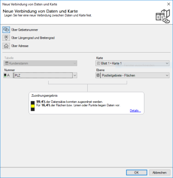
In case of a placement via area numbers, you have to specify via which column easymap can create a reference to the area levels. you have already selected a table for the analysis. If your setting is not correct, go back one step and select another table. Furthermore, you can specify under map for which sheet this assignment should be valid. The currently selected sheet for preselected. At number please select the column from your data in which the exact designation for the area plane is available (e.g. the postal code). Select at level you can see directly how good your assignment is. You can find further information on the assignment result in here.
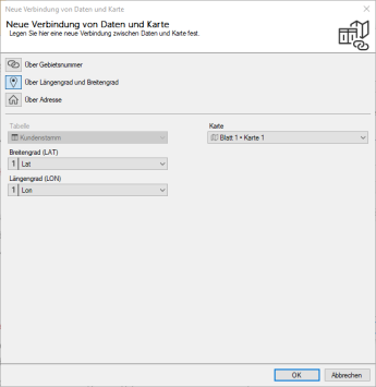
For placement using geographic coordinates, you can specify the columns for Latitude and Longitude. The possible columns are selected from the already selected table. If the correct table is not selected, set this one step in advance. In Map, you also have the option of setting on which map and which sheet you want to set up this new connection.
From the table already selected, from the previous step, select the appropriate columns for the calculation. Assign the data column with the street information to the field street. For the fields house number, postcode, location and country you can also select a suitable column of your table. easymap already offers you a suggestion for a possible selection. In addition, you have the possibility to set at map on which map and which sheet you want to set up this new connection.
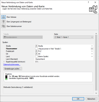
Check if easymap can assign and place your data records according to your settings. To do so, click on the button check settings. easymap will now check the first ten data records of your table and determine the quality of the results. Based on the quality, you can decide whether you want to continue to place your data records via the address or whether you should choose another placement method.
