
Basic concepts
Territory structures and their terminology are not familiar to everyone. In the following we have briefly explained the most important terms.
The EasyMap DistrictManager Edition offers all commands for creating, changing and optimizing a territory structure in the menu Territory organization and in the context menus for the control window Territory organization. In order to prevent the user from unintentionally making changes to a territory structure, the commands for creating, changing and optimizing areas and locations must first be activated with the command Planning mode On. It is recommended to switch off the planning mode immediately after finishing the editing of the territory structure with the command Planning mode Off in order to exclude unintentional further changes to the territory structure.
EasyMap requires a corresponding planning basis for territory and location planning. Often you use a digital map for this. The map used as a basis for planning is then called the "base map". It contains the basic building blocks for the formation of territories and forms the geographical framework for area and location planning.
Instead of a digital map, EasyMap can also use the addresses of customers, target groups, location lists or similar for which coordinates are available as a planning basis. In this case, EasyMap generates a so-called point plane from the addresses or location coordinates and uses it as a base map. The advantage: If, for example, the postcode map is used as a base map, the smallest plannable unit is the area of a postcode. If different customers have the same postal code, but are to be assigned to different sales representatives, this would not be possible. If, on the other hand, a point level based on the customer addresses is used as the base map, the smallest plannable unit is the individual customer. This means that customers with the same postal code can be assigned to different sales representatives.
In the EasyMap DistrictManager Edition, the word "Territory" is used as a generic term for the areas to be planned. In practice, the most diverse designations are used for this purpose: representative district, sales area, sales region, service room, etc. A territory is any combination of bricks. A territory may consist of several non-continuous sub-areas.
In a territorial organization with several hierarchical levels, the word "territory" is used as a general generic term for the territories in any hierarchical level.
In EasyMap, territories are formed by combining the basic building blocks. If a digital map is used as a basis for planning, a basic building block corresponds to one element of the basic map. If, on the other hand, a point level is used as the base map, each individual customer, each individual address or each individual location is a base building block.
| Elementary bricks | Base map |
Territories |
|---|---|---|
| Postal code areas (areas) | postcode map | Territories |
| Customers | Point level (generated from customer addresses) | Commercial agent districts |
| Municipalities (areas) | Municipal boundary map | Franchise territories |
| Roads or road sections (lines) | Road network | Districts for brochure distribution |
| Buildings | Point plane (generated from the building coordinates) | Carrier districts for newspaper delivery |
For territory organizations with more than one hierarchy level, EasyMap distinguishes, where necessary, between bricks and basic blocks. The term "basic building blocks" has already been defined above. The territory at the lowest hierarchical level are made up of the basic building blocks. The territory of the lowest hierarchy level are in turn the "bricks" for the higher hierarchy level, and so on.
The term "territory" is used in EasyMap as a general generic term for any element of an territory organization as well as for any areas in digital maps. Particularly if the user also calls the areas in "his" organization "territory", special attention is required to avoid confusion.
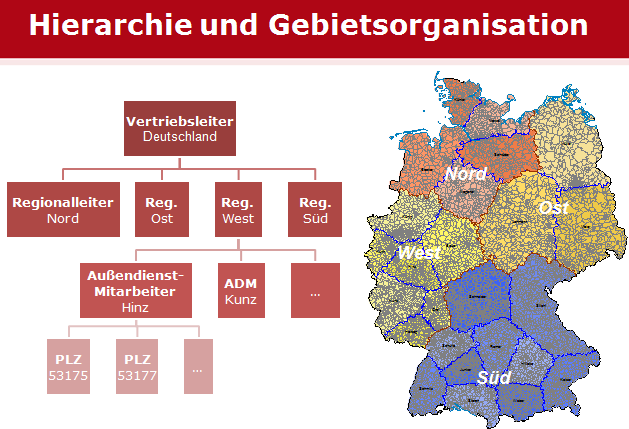
In large sales and service organizations, there is usually also a hierarchically structured territory organization. For example, area sales managers are often responsible for an entire region. Sales representatives who each have a specific work area within the region to look after are subordinate to them. Each field service district can be defined by a set of postal codes.
EasyMap uses numbers to uniquely identify areas, because names often prove to be disadvantageous for identification purposes, for example because there are often differences in spelling or abbreviations. Common numbering systems in the base maps are, for example, postal codes and official municipal and district codes. EasyMap also identifies the territory on the basis of numbers. These may consist of numbers and letters.
Territory numbers: hierarchically structured or freely assigned
In the case of territorial organizations with more than one hierarchical level, the numbering system for the territories can also be structured hierarchically. To do this, you specify that the leading n digits of an area number represent the number of the higher-level area level. This corresponds to the numbering system in many large hotels: the first digit of the room number indicates the floor, the following two digits the consecutive number of the room on the floor.
Example 2: The 5-digit postal code in Germany contains the number of the postal zone (= the first digit of the postal code) and the number of the postal region (= the first two digits of the postal code). Postal code area 53175 is therefore located in postal code region 53 and this is in zone 5.
Example 3: The official 8-digit municipality code number is structured hierarchically as follows:
Point 1-2: State
Paragraphs 1-3: Administrative district
Numerals 1-5: Circle
Numbers 1-8: Community
Gemeinde Much (Gemeidekennziffer 05382036) belongs to the Rhein-Sieg district (Kreiskennziffer 05382); this belongs to the administrative district of Cologne (Reg.-Bez. 053) in the federal state of North Rhine-Westphalia (Land 05).
If your territory organization is structured hierarchically, a strictly hierarchical numbering system offers some advantages, e.g. that you can always see from the territory number alone to which superior unit a territory belongs. Nevertheless, you can assign the numbers of the areas for each level freely, i.e. independently of the numbers of the areas in other levels. These offer considerably more freedom in the area construction, e.g:
- Multiple assignments (that is, a postal code can, for example, be assigned to different sales representatives at the same time)
- so-called branching (i.e. one can, for example, simultaneously represent the "old" and the "new" regions above the same sales force districts)
- There are no restrictions when inserting or deleting intermediate levels
- Locks often have a more far-reaching effect on hierarchical area numbers
Locations
Locations as well as territories can be the subject of planning, analysis and optimisation. Locations can be inserted, changed or deleted manually. Location lists can also be imported. If there are no coordinates for the locations, the number of the area in which the location is located (e.g. the postcode) can be used as a substitute. In this case, the location shall be set at the centre of the area concerned. EasyMap distinguishes between district-related locations and other locations.
Territory-related locations belong to the territorial organization of the own company, e.g. sales locations such as regional headquarters, branches, dealer locations, offices of field staff, etc.
EasyMap assumes by default that a location is assigned to exactly one territory (1:1 assignment) and that multiple assignments are not allowed. If this is not desired, the option Allow multiple assignments must be ticked when creating a location level. A site can then be assigned to several territories at the same time, or a territory can have several sites.
In addition to numbers, names and other data, locations can also be assigned capacities. These can be considered as weighting in optimizations. For example, the different performance capabilities of field staff can be included in the calculations. Example: If the "old hand" is to receive an area that is 20% larger than the average due to his experience, a weighting or capacity of 120% would be assigned to him. If the newcomer is to be trained in an area that is 20% smaller than the average, they would be assigned a weighting of 80%.
